Updates
- Originally published, August 31, 5:03 pm.
- August 31, 6:46 pm:
- Updated the 72-hour gif. Dorian is really getting close to those northwestern Bahama Islands now.
- August 31, 7:37 pm:
- I’m having real trouble visualizing that there’s much of anywhere on the northwestern Bahama Islands to evacuate to, but I guess that’s what they’re doing.[1]
- August 31, 8:18 pm:
- Updated the National Hurricane Center forecast storm track map for Dorian. They appear not to have a revised tropical storm wind forecast map.
- Updated the 72-hour gif. Dorian still looks like it is headed straight for the northwestern Bahama Islands.
- Updated commentary on Dorian.
- August 31, 10:15 pm:
- Updated the 72-hour gif. If you’re in the northwest Bahamas, this must be terrifying.
The Amazon
There is a new blog post entitled, “A hurricane, a burning rainforest, and economic survival: Why we cannot view these problems separately.”
Max Fisher, “‘It’s Really Close’: How the Amazon Rainforest Could Self-Destruct,” New York Times, August 30, 2019, https://www.nytimes.com/2019/08/30/world/americas/amazon-rainforest-fires-climate.html
Gabriel Stargardter, “Why is Bolsonaro wary of foreign Amazon aid? Ask Brazil’s military,” Reuters, August 30, 2019, https://www.reuters.com/article/us-brazil-environment-military/why-is-bolsonaro-wary-of-foreign-amazon-aid-ask-brazils-military-idUSKCN1VK2HQ
Dorian
I have to say that the Bermuda High, previously thought likely to steer Dorian directly into Florida,[2] just doesn’t look very convincing to me at all.
In all fairness, I’m used to looking at the Pacific High, which shields much of the U.S. west coast from storms during the summer. And this Bermuda High thing just isn’t anywhere near as persuasive. Seriously, this is pathetic by comparison. And they really thought this was gonna stop Dorian from going north?
72-hour gif, images two hours apart, as of 10:00 pm.
I wouldn’t have been surprised to see Dorian turn north well before the forecast in the Washington Post story, in which Dorian would have skirted much of the east coast right up through North Carolina’s Cape Hatteras.[3] The more recent forecast storm track puts the storm a little further off shore and seems much more reasonable to me.
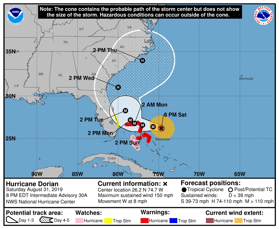
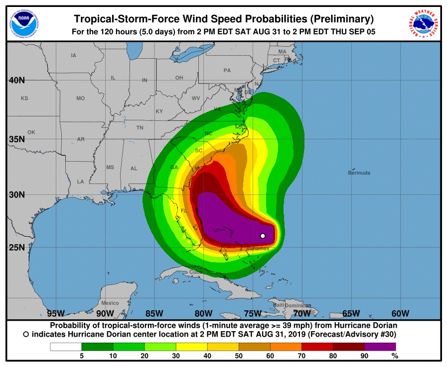
National Hurricane Center maps, August 31, 2019.
Leila Macor, “Bahamas braces as monster Hurricane Dorian heads for US mainland,” Yahoo! News, August 31, 2019, https://news.yahoo.com/puerto-rico-braces-hit-tropical-storm-dorian-133659477.html
Jason Samenow, “‘Extremely dangerous’ Hurricane Dorian barrels toward Southeast U.S. as likelihood of direct hit on Florida decreases,” Washington Post, August 31, 2019, https://www.washingtonpost.com/weather/2019/08/31/extremely-dangerous-hurricane-dorian-churns-toward-southeast-us-florida-forecast-is-highly-uncertain/
- [1]Leila Macor, “Bahamas braces as monster Hurricane Dorian heads for US mainland,” Yahoo! News, August 31, 2019, https://news.yahoo.com/puerto-rico-braces-hit-tropical-storm-dorian-133659477.html↩
- [2]Jason Samenow, Matthew Cappucci, and Andrew Freedman, “Potentially disastrous Hurricane Dorian strengthens to Category 4 as it targets Florida and Southeast U.S.,” Washington Post, August 30, 2019, https://www.washingtonpost.com/weather/2019/08/30/potentially-disastrous-hurricane-dorian-looms-closer-stronger-targeting-florida-southeast-us/↩
- [3]Jason Samenow, “‘Extremely dangerous’ Hurricane Dorian barrels toward Southeast U.S. as likelihood of direct hit on Florida decreases,” Washington Post, August 31, 2019, https://www.washingtonpost.com/weather/2019/08/31/extremely-dangerous-hurricane-dorian-churns-toward-southeast-us-florida-forecast-is-highly-uncertain/↩