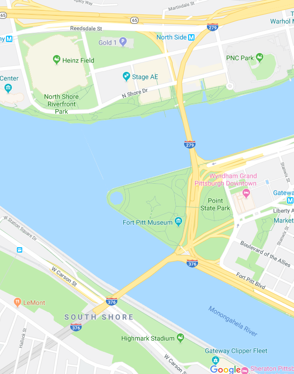
Fig. 1. Screenshot from Google Maps, September 22, 2019, covering downtown, the Fort Pitt and Fort Duquesne Bridges and environs. The Fort Pitt Tunnel extends to the southwest from the Fort Pitt Bridge. Another piece of the mess here is Pennsylvania Route 28 (not shown) which follows the north shore of the Allegheny River and connects to Route 65 very near the interchange with I-279. Two rivers are unidentified: The Allegheny approaches from the upper right. It and the Monongahela are tributaries combining to form the Ohio which proceeds to the left.
One place traffic really gets bad is around the Fort Pitt and Fort Duquesne Bridges (figure 1). These two bridges cross the Monongahela and Allegheny Rivers respectively, very near the Point (where historically Forts Duquesne and Fort Pitt stood) where these two rivers combine to form the Ohio River. They aren’t very far apart and there are a lot of directions of entry and a lot of directions of exit and a limited number of lanes on each of the bridges. This means there is a ludicrous number of lane changes that can only happen in a ludicrously short space (the rivers are wide but not that wide). If you don’t do this right, you’ll find yourself headed in entirely the wrong direction.
So pay attention: If, for example, you’re getting on the Fort Duquesne Bridge from Pittsburgh’s North Shore, where there are two major sports stadiums, a casino, the Carnegie Science Center (a museum), and Stage AE (a major entertainment venue), among other things, and you mean to head towards Banksville Road or I-376 west towards the airport, Google will tell you to use the second from the right lane, which can be a problem because that lane and the second from the left lane coming from I-279 south, which you’re actually merging onto, are where lots and lots of lane changes need to happen in a very short space. This gets horribly backed up. So you might want to stay in the far right lane until you’re almost past the exits for Fort Duquesne Boulevard and the Strip District, then, as you get on the Fort Pitt Bridge, start working your way over to the left two lanes, but look out, because you don’t want to end up on I-376 east towards Monroeville. There are also on-ramps on each side here. All in very short spaces. All with people meaning to do the opposite things from you and changing lanes in the other direction.
Similar fussiness applies in the opposite direction, where you might be headed toward Fort Pitt Boulevard, Boulevard of the Allies, Fort Duquesne Bridge, the Strip District, Pittsburgh’s North Shore, I-279 north, Pennsylvania Routes 28 or 65, and all the permutations therefrom. This is absolute madness and because of it, traffic approaching the Fort Pitt Tunnel on I-376 east backs up for miles, often past Carnegie.
In this, the northbound direction, each lane (of four) has a particular purpose, and this is something you want to be thinking about before you hit the Fort Pitt Tunnel, where no lane changes are permitted, or as you merge onto the Fort Pitt Bridge from West Carson Street (Pennsylvania Route 837 South):
-
The leftmost lane on the Fort Pitt Bridge takes you to the Fort Duquesne Bridge. Once you’re on the Fort Duquesne Bridge, again there are four lanes, but you have a bit more flexibility. Choose the leftmost or second-from-left lane if you want Reedsdale Street exit, the center two lanes if you want Pennsylvania Route 65 north, the right two lanes if you want I-279 North, and the rightmost lane if you want Pennsylvania Route 28 North.
-
The second-from-left lane on the Fort Pitt Bridge is for the Tenth Street Bypass or Fort Duquesne Boulevard, not the Fort Duquesne Bridge.
-
The second-from-right lane on the Fort Pitt Bridge is either for the Liberty Avenue exit or to continue on I-376 East. Use this lane if you intend to use the Grant Street exit from I-376 East.
-
The rightmost lane on the Fort Pitt Bridge is strictly for I-376 East. Unless you change lanes, it will ultimately feed you onto the Forbes Avenue exit.
This page is part of a section on driving in Pittsburgh: