If you aren’t confused by the time you finish reading this section, you just aren’t paying attention. It’s that bad. Oh, and Google Maps doesn’t know about it, so you won’t get any help there.
First, to explain, the Liberty Tunnel is a major route connecting the South Hills area of Pittsburgh with the Liberty Bridge which in turn feeds on to all sorts of possible routes into downtown, near and away from downtown, and the Veterans Bridge. Pittsburgh navigation is complicated and this is only one example. The Liberty Bridge (figure 1) crosses the Monongahela River and is separated from the Tunnel by a single intersection where turns are restricted but also offers possibilities of heading toward the South Side area, up towards Mount Oliver, and down towards Station Square.
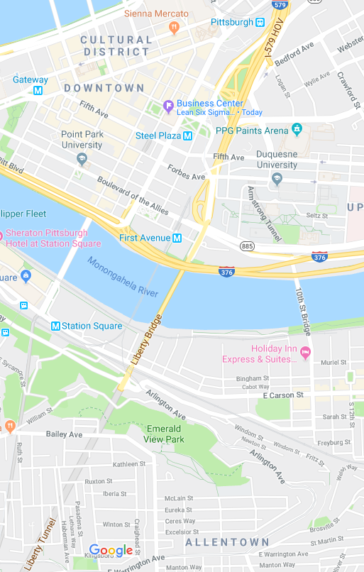
Fig. 1. Screenshot from Google Maps, September 22, 2019, covering the connection of the Liberty Tunnel to the Liberty Bridge and the mess of interchanges leading in the general direction of the Veterans Bridge (not shown, but crossing the Allegheny River to the north).
On weekdays from 2:00 pm to 6:00 pm, the Liberty Bridge, with otherwise has two lanes in each direction, switches to three lanes in the southbound (out of downtown, toward South Hills) direction and one lane in the northbound (inbound) direction.
Even during such times, there are two lanes in the northbound (inbound) direction in the Liberty Tunnel. See above: No lane changes are permitted in the tunnel. During these times, the right lane in the tunnel very rapidly emerges into a right turn only lane toward the South Side district. If you’re heading to or through downtown, you need the left lane. Yes, that’s the one with all the cars in it.
Conversely, during such times, in the southbound direction (toward the South Hills, out of downtown), the right lane on the Liberty Bridge emerges onto a right turn only lane toward Mount Washington.
At all times, the Liberty Tunnel, in the southbound direction, also has exactly two lanes. The right lane emerges from the tunnel to a ramp for southbound Pennsylvania Route 51, toward Uniontown, with a very short space to change lanes out. You would also use the right lane if you mean to head north on Route 51.
Remember that there are no lane changes permitted in the tunnel. So this means that if you’re heading for West Liberty or Washington Road beyond, during that weekday 2:00 pm to 6:00 pm timeframe, you’ll want the left lane on the Liberty Bridge. If you’re heading toward Route 51, you’ll want the middle lane. And if you’re heading for Mount Washington, you’ll want the right. Figure it out no later than when you’re on the bridge and preferably sooner because traffic will be heavy.
The next booby trap on the Liberty Bridge occurs in the northbound direction and Google Maps doesn’t recognize that there’s any issue here at all. At some point you suddenly have three or four lanes in the northbound direction, all seemingly going straight. But the right two lanes are an exit for Boulevard of the Allies. When Google doesn’t tell you to go toward Boulevard of the Allies, that means you want the left one or two lanes (depending on whether or not it’s a weekday between 2:00 pm and 6:00 pm).
Do you have a headache yet? Because there’s more: When there are two lanes available in the northbound direction, the left rapidly becomes an exit only lane for 6th Avenue as it crosses onto land. If you want 7th Avenue (which, at this writing, will be closed for a while for construction), you want the right lane, which is the same lane as for a bunch of other options that come up in a very short space. But Google won’t tell you that you need to bear left because you’re now on “Crosstown Boulevard,” which you won’t find marked as such anywhere near (but is referenced on signs at some distance away on Boulevard of the Allies), and it thinks that’s straight.
Those other options, which Google thinks comprise an “exit,” include Centre Avenue, Bedford Avenue, Bigelow Boulevard, and Interstate 579 leading across the Veterans Bridge towards Pennsylvania Route 28 and Interstate 279. This is a god-awful mess that is nowhere near adequately marked, especially when approached from downtown. The closest analog I can think of is the MacArthur Maze in Oakland, California, but I think the MacArthur Maze is better marked. I know Google Maps does a better job of navigating through the MacArthur Maze; it is almost no help at all navigating through this from multiple directions with no time at all to figure out what you’re doing.
Think fast.
This page is part of a section on driving in Pittsburgh: